Drones: The New Way to Check Power Lines
You know, checking power lines used to be a real pain. People had to climb up there or use helicopters, which sounds pretty risky and expensive. But now, there’s this new way using drones. It’s changing how utility companies do their inspections, making things safer and quicker. We’re talking about power line inspection drones here, and they’re becoming a pretty big deal.
Key Takeaways
- Power line inspection drones use advanced tech like thermal cameras, LiDAR, and AI to spot problems, replacing dangerous manual checks.
- These drones collect detailed visual, thermal, and structural data, providing a clear picture of power line conditions.
- Using drones makes inspections much safer for workers by keeping them on the ground, away from hazards.
- Drones significantly cut down inspection time and costs compared to traditional methods like helicopters or climbing.
- The precise data gathered by power line inspection drones allows for better planning of maintenance and repairs, improving grid reliability.
Revolutionizing Power Line Inspections With Drones
The Evolution of Power Line Inspection
Remember the old days? Inspecting power lines meant climbing poles, using helicopters, or just squinting from the ground. It was slow, risky, and frankly, not very detailed. Workers put themselves in harm’s way, and sometimes, problems were missed until they became big, expensive issues. It was a tough job, and the tools just weren’t keeping up with the demands of maintaining our ever-growing electrical grid. We needed a better way, something that could get close without getting hurt.
Introducing Power Line Inspection Drones
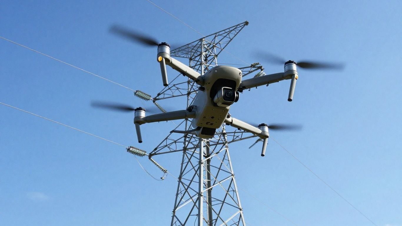
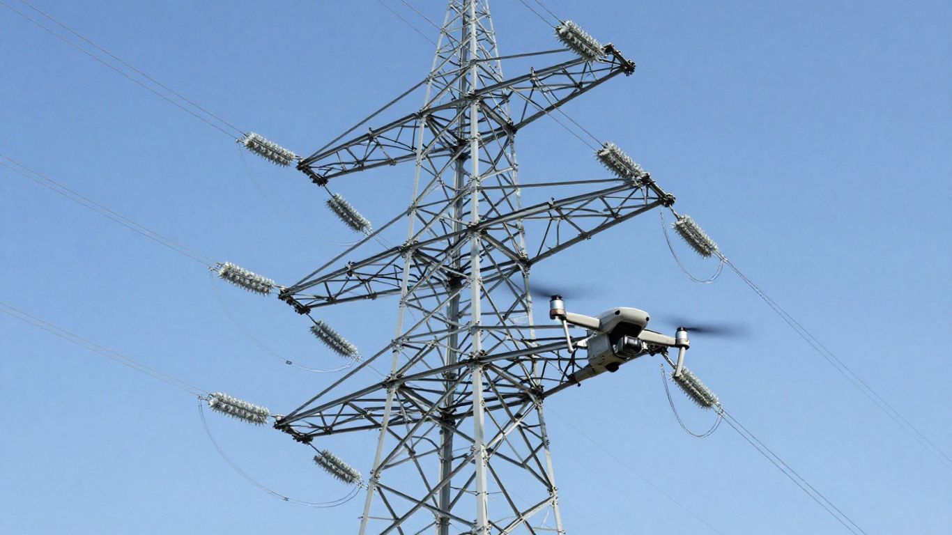
Now, we’ve got drones. These aren’t your hobbyist toys; these are specialized machines built for serious work. Think of them as flying robots that can get right up close to power lines, wires, and poles, all while the operator stays safely on the ground. They’re changing the game for utility companies. These drones can carry all sorts of fancy equipment, like high-resolution cameras and thermal sensors, to see things we couldn’t see before. It’s like giving inspectors super-vision, but from a safe distance. This technology allows for more efficient and effective monitoring and upkeep of power infrastructure. This technology is really making a difference.
Key Technologies in Drone Inspections
What makes these drones so special? It’s the tech they carry. We’re talking about things like:
- Thermal Imaging: This lets us see heat. If a connection is overheating, a thermal camera spots it instantly, flagging potential problems before they cause a blackout or a fire. It’s great for finding hidden electrical faults.
- LiDAR: This uses lasers to create detailed 3D maps of the area. It’s super useful for checking if trees are getting too close to the power lines – a common cause of outages. It also helps assess the physical condition of poles and towers.
- High-Resolution Cameras: Obvious, right? But these cameras capture incredibly detailed images and videos. We can zoom in on tiny cracks, corrosion, or loose fittings that would be impossible to spot from afar.
- AI Defect Detection: This is where things get really smart. Artificial intelligence can analyze the data collected by the drones, automatically identifying potential defects and anomalies. It speeds up the review process and helps ensure nothing gets missed. These advanced tools allow for detailed evaluations, improving the efficiency and reliability of power infrastructure maintenance. Powerline inspection drones are a big step forward.
How Power Line Inspection Drones Operate
So, how exactly do these high-tech gadgets get the job done? It’s a pretty neat process, really. Instead of sending people up rickety poles or relying on noisy helicopters, drones take over the heavy lifting, so to speak. They’re equipped with a bunch of cool sensors that gather all sorts of information.
Data Collection Capabilities
These drones are basically flying data centers. They can carry high-resolution cameras to snap detailed pictures of wires, insulators, and poles, looking for cracks, corrosion, or wear. But it gets more interesting. They often have thermal imaging cameras. These cameras detect heat, so if a component is overheating – a sign of a potential problem – the drone can spot it from a safe distance. Think of it like a heat map for the power grid. On top of that, some drones use LiDAR. This technology uses lasers to create a 3D map of the power lines and the surrounding area. This is super useful for checking how close vegetation is getting to the lines, which is a big fire risk, or for assessing the structural integrity of the poles themselves. The data collected is incredibly detailed, allowing for a much closer look than was ever possible before.
Real-Time Analysis and Reporting
What’s really changing the game is that many of these drones can process data right there in the air. This means they can flag potential issues almost instantly. Instead of waiting days for a report, you might get an alert on your tablet while the drone is still flying. This allows for quicker decision-making. If a critical component is overheating, you can reroute power or dispatch a repair crew much faster. This real-time feedback loop is a huge step up from older methods where data analysis took ages. It means maintenance can be more proactive, preventing bigger problems down the line. This kind of immediate insight is a big reason why companies are looking into drone inspection services.
Navigating Complex Grids
Flying a drone through a maze of power lines, especially in rough terrain or busy urban areas, sounds tricky, right? Well, these drones are built for it. They use advanced GPS and navigation systems, often with features like obstacle avoidance, to fly safely and precisely along the power lines. Many can fly beyond the visual line of sight (BVLOS), meaning the operator doesn’t have to see the drone at all times. This is crucial for covering long stretches of transmission lines efficiently. They can be programmed with specific flight paths, ensuring every inch of the infrastructure is checked systematically. This precision means fewer areas are missed and the inspection process is more thorough, which is also a benefit seen in other industries like wind turbine inspections.
The ability to fly autonomously along pre-programmed routes, coupled with sophisticated sensors, means that even the most complex and remote power line networks can be inspected with unprecedented regularity and detail. This shift from manual checks to automated drone surveys is transforming how utility companies manage their assets.
Benefits of Utilizing Drones for Power Line Checks
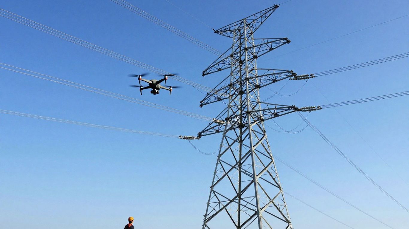
Enhanced Safety for Inspection Crews
Working on or around high-voltage power lines is inherently risky. Traditional methods often require crews to climb poles, work at extreme heights, or get close to energized equipment. This puts them in direct danger from falls, electrical hazards, and difficult weather conditions. Drones completely change this dynamic by allowing inspections to be conducted from the ground. Operators can pilot these unmanned aerial vehicles (UAVs) from a safe distance, significantly reducing the risk of accidents and injuries. This shift means fewer personnel are exposed to danger, making the entire process much safer for utility workers. It’s a big win for worker well-being and helps utility companies meet stringent safety regulations.
Significant Time and Cost Savings
Think about how long it used to take to inspect miles of power lines. It often involved specialized vehicles, multiple crew members, and days, if not weeks, of work. Drones, however, can cover vast distances much faster. With their ability to fly directly to inspection points and capture data rapidly, they can complete tasks in a fraction of the time. This speed translates directly into cost savings. You need fewer people on-site, less specialized equipment like bucket trucks or helicopters, and less time spent on the job. This efficiency is especially noticeable during emergency situations, like after a storm, where quick assessments are needed to restore power. The ability to perform automated power line surveys quickly means faster repairs and less downtime for customers.
Improved Accuracy and Data Quality
When you’re up close, it’s easy to miss small details. Drones, equipped with advanced sensors like high-resolution cameras, thermal imaging, and LiDAR, capture incredibly detailed information. Thermal cameras can spot overheating components that might signal an impending failure, while LiDAR can map the surrounding environment and measure vegetation encroachment with precision. This level of detail allows for the early detection of minor issues that could become major problems later. The data collected is often geotagged and can be analyzed in real-time or post-flight, providing a clear, objective record of the power line’s condition. This makes for more informed maintenance decisions and helps extend the lifespan of the infrastructure. It’s a much more thorough approach to remote power grid assessment.
The shift to drone-based inspections isn’t just about doing things faster or cheaper; it’s about doing them smarter. The detailed, objective data gathered allows utility companies to move from reactive repairs to proactive maintenance, preventing outages before they happen and optimizing the performance of the entire grid.
Advanced Technologies in Drone Power Line Inspections
When we talk about drone power line monitoring, it’s not just about flying a camera around anymore. The tech packed into these machines is pretty impressive, making the whole process smarter and more effective. We’re seeing a lot of advanced tools that help us see things we couldn’t before, or at least see them much better.
Thermal Imaging for Anomaly Detection
One of the biggest game-changers is thermal imaging. Think of it like giving the drone an X-ray vision for heat. These cameras can spot "hotspots" on power lines or equipment. These hot spots often mean there’s a problem brewing, like a loose connection or overloaded component, that could lead to a failure. Catching these early means we can fix them before they cause a blackout. It’s a huge step up from just looking for visible damage.
LiDAR for Structural and Vegetation Analysis
Then there’s LiDAR. This technology uses lasers to create incredibly detailed 3D maps of the power lines and everything around them. It’s fantastic for checking the physical condition of the poles and wires themselves. More importantly, it’s a lifesaver for managing vegetation. LiDAR can precisely measure how close trees and branches are to the lines, helping utility companies prevent outages caused by overgrowth. This kind of detailed mapping is something that used to take a lot more time and effort.
AI-Powered Defect Identification
Finally, we’ve got Artificial Intelligence (AI) stepping in. After the drone collects all the visual, thermal, and LiDAR data, AI software can sift through it. It’s like having a super-fast, tireless assistant that can spot tiny defects or patterns that a human might miss. This AI can identify things like cracked insulators, corrosion, or even subtle signs of wear and tear. It helps speed up the analysis process significantly and makes sure that no potential issue gets overlooked. Using a UAV for electrical infrastructure checks is becoming more common because of these smart tools.
The integration of these advanced sensors and AI means that drone power line monitoring is moving beyond simple visual checks. It’s becoming a sophisticated diagnostic tool that provides deep insights into the health of the grid. This allows for more proactive maintenance and fewer unexpected failures, which is good for everyone involved.
The Practical Application of Power Line Inspection Drones
So, how does this all actually work out in the field? It’s not just about flying a drone around; there’s a whole process involved in making sure these aerial utility inspection missions are effective. It starts before the drone even leaves the ground.
Pre-Inspection Planning and Route Mapping
First off, you’ve got to plan. This isn’t like just hopping in your car and driving somewhere. For power line work, you’re looking at mapping out the exact flight path. This involves considering things like the terrain, any no-fly zones, and the specific assets you need to inspect. Software helps here, letting operators define precise routes, altitudes, and speeds. This planning stage is super important for making sure the drone covers everything it needs to without wasting time or battery. It also helps avoid potential issues, like getting too close to obstacles or flying in restricted airspace. This detailed planning is key to a successful and safe inspection.
Data Acquisition During Flight
Once the drone is up, it’s all about collecting good data. Drones equipped with specialized sensors, like thermal cameras and LiDAR, are doing the heavy lifting. Thermal imaging is great for spotting overheating components, which could signal a problem before it gets serious. LiDAR, on the other hand, is used to create detailed 3D models of the power lines and the surrounding environment. This helps in assessing structural integrity and checking for vegetation that might be growing too close to the lines. The ability to fly Beyond Visual Line of Sight (BVLOS) is a game-changer here, allowing drones to cover vast distances without the operator needing to see the drone directly. AI-powered defect identification is also starting to play a bigger role, helping to flag potential issues in real-time as the data comes in. It’s pretty wild how much information can be gathered from the sky.
Post-Flight Analysis and Maintenance Recommendations
After the drone lands, the work isn’t over. All that data needs to be processed. This usually involves specialized software that can analyze the high-resolution images, thermal readings, and LiDAR scans. The goal is to identify any anomalies, like damaged insulators, corroded connections, or vegetation that needs trimming. Based on this analysis, maintenance teams get clear recommendations on what needs to be done, where, and why. This makes the whole maintenance process much more targeted and efficient. Instead of just guessing where problems might be, you have concrete data to guide your actions. This leads to quicker repairs and helps prevent bigger outages down the line. It’s a pretty neat system for keeping the lights on.
The shift to drone-based inspections means utility companies can gather more detailed information than ever before. This data-driven approach allows for proactive maintenance, reducing the likelihood of unexpected failures and improving the overall reliability of the power grid. It’s a smarter way to manage critical infrastructure.
Choosing the Right Drone for Power Line Work
So, you’re looking to get into drone inspections for power lines. That’s a smart move, but picking the right tool for the job is key. It’s not just about grabbing any drone off the shelf; you need something that can handle the specific demands of inspecting miles of electrical infrastructure.
Payload Capacity and Sensor Integration
When you’re looking at drones, the first thing to consider is what it can carry. Power line inspections often require specialized sensors. Think high-resolution cameras for spotting tiny cracks or corrosion, but also thermal cameras to detect overheating components – a major safety concern. Some jobs might even need LiDAR for detailed 3D mapping of the lines and surrounding environment, especially for vegetation management. The drone needs to be able to lift these sensors reliably and keep them stable during flight. You’ll want to check the drone’s maximum payload weight and see if it supports the specific sensors you need. Sometimes, you might need to integrate multiple sensors for a single mission, so compatibility is a big deal. Investing in the right sensors can significantly increase startup expenses, sometimes by tens of thousands of dollars, so plan carefully.
Flight Time and Range Considerations
Power lines stretch for miles, and you can’t just land and swap batteries every ten minutes. You need a drone that can stay airborne long enough to cover a good section of the grid. Look for drones with extended flight times, often achieved through efficient design and powerful batteries. The range is also important; you want to be able to operate the drone safely from a distance, especially when dealing with high-voltage lines. Some advanced operations might even require Beyond Visual Line of Sight (BVLOS) capabilities, which means the drone can fly further than you can see it. This requires specific regulatory approval and a drone system designed for such missions.
Precision Navigation Systems
Accuracy is everything when you’re inspecting critical infrastructure. You need a drone that can hold its position precisely, even in windy conditions, and follow pre-programmed flight paths with incredible accuracy. Look for drones equipped with advanced GPS systems, like RTK (Real-Time Kinematic) GPS, which can provide centimeter-level positioning. This is vital for repeatable inspections and for pinpointing the exact location of any issues found. A drone pilot’s role is expanding significantly, driven by demand in infrastructure inspection and monitoring, so having reliable navigation is a must for skilled drone pilots.
The complexity of modern power grids means that simple visual checks are no longer enough. Drones equipped with sophisticated sensors and navigation systems allow for data collection that was previously impossible or prohibitively expensive. This shift is not just about efficiency; it’s about safety and reliability for the entire energy network.
Here’s a quick rundown of what to prioritize:
- Payload: Can it carry the cameras (visual, thermal) and LiDAR you need?
- Flight Time: How long can it stay up? Aim for 30+ minutes for most utility work.
- Range: How far can it operate safely from the ground control station?
- Navigation: Does it have RTK GPS or similar for pinpoint accuracy?
- Durability: Can it withstand various weather conditions?
Choosing the right drone is an investment, but it pays off in safer, more efficient, and more accurate inspections. It’s about getting the right data to make informed decisions about maintaining our power infrastructure.
The Future is Flying
So, it’s pretty clear that drones are changing the game when it comes to checking power lines. They’re way safer than sending people up poles or using helicopters, and they get the job done faster. Plus, all the cool tech like thermal cameras and LiDAR means we’re getting super detailed info, helping to spot problems before they even happen. It just makes sense for utility companies to look into this. It’s not just about being modern; it’s about being more efficient, saving money, and keeping everyone safer. Looks like the sky’s the limit for these flying inspectors.
Frequently Asked Questions
How do drones check power lines?
Drones are like flying robots that can carry special cameras and sensors. They fly close to power lines and take pictures or use tools like thermal cameras to see if anything is wrong, like hot spots or damaged wires. This way, people don’t have to climb up high or go to dangerous places.
Are drones safer than old ways of checking power lines?
Yes, much safer! Before drones, people had to climb tall poles or use helicopters, which was risky. Drones let inspectors check from the ground, keeping them away from danger like falling or electrical shocks.
Can drones see problems that people might miss?
Absolutely. Drones can have special cameras, like thermal ones that see heat. This helps find problems like wires getting too hot, which is hard to see with just your eyes. They also collect super clear pictures and information.
How fast can drones check power lines compared to people?
Drones are way faster. What might take people days or even weeks to check can often be done by a drone in just a few hours. This means power companies can find and fix problems much quicker.
What kind of information do drones collect?
Drones collect lots of useful information. They can take detailed photos of wires and poles, use thermal cameras to spot overheating parts, and even use special scanners called LiDAR to create 3D maps of the power lines and nearby trees. This helps them see if trees are growing too close.
Do drones help save money on checking power lines?
Yes, they do! Using helicopters or sending large crews to check lines costs a lot of money. Drones are less expensive to operate, need fewer people, and help find problems early, which means fewer costly repairs down the road.