
Unlock Precision: The Benefits of Drone Mapping Services for Your Project
Thinking about your next big project? Maybe you’re building something, or perhaps planning out a new area for the town. It can get pretty complicated, right? Well, there’s a way to make things a lot clearer and more accurate. Drone mapping services are changing how we get information about a site. Instead of spending ages on the ground, a drone can fly over and grab all the details you need, super fast. This means less guesswork and more solid facts to work with, which is a win for everyone involved.
Key Takeaways
- Drone mapping services speed up how you collect site information, cutting down on manual work and potential mistakes.
- You get real-time updates on your project’s progress, helping you spot problems early and manage resources better.
- Precise measurements from drones help in creating more accurate project plans and cost estimates, keeping you on budget.
- These services provide a complete picture of complex sites, improving planning and reducing the chance of errors during construction.
- Drone mapping makes it easier to share site information with everyone on the project, improving teamwork and communication.
Streamlining Data Collection and Analysis with Drone Mapping Services
Remember the old days of surveying? Lots of walking around, taking measurements by hand, and then spending ages trying to make sense of it all. It felt like it took forever. Well, drone mapping is changing that game. It’s like giving your project a super-fast, super-accurate set of eyes in the sky. Instead of days or weeks, you can get detailed site information in hours. This means less time spent on the grunt work of data gathering and more time actually using that information to move your project forward.
Automated Data Capture for Efficiency
Forget about having a whole crew out there with tripods and measuring tapes. Drones can fly themselves, following pre-planned routes to capture exactly what you need. This automated process does a couple of things. First, it cuts down on the number of people needed on site, which is a big win for safety and labor costs. Second, it makes sure you get consistent data every single time. No more worrying about someone missing a spot or making a simple measurement mistake. It’s all done automatically, giving you a reliable dataset right from the start.
Rapid Data Processing for Actionable Insights
Okay, so you’ve got all this data from the drone – tons of photos, maybe some laser scans. What do you do with it? That’s where the processing software comes in. It takes all that raw information and turns it into useful maps, 3D models, and reports. This isn’t just about pretty pictures; it’s about getting insights. You can quickly see things like site topography, existing structures, or progress made. This speed means you’re not waiting around for days to find out what’s going on. You get the information fast, so you can make decisions quickly.
Seamless Integration with Existing Workflows
One of the best parts is that this new tech doesn’t usually mean throwing out all your old systems. Drone mapping software is designed to play nice with the tools you’re probably already using. Think about CAD software, BIM models, or project management platforms. The data you get from drones can often be plugged right into these systems. This makes it easier for your team to adopt the technology without a massive overhaul. It just fits into how you already work, making the whole process smoother and more connected.
The shift from manual data collection to drone-based methods isn’t just about speed; it’s about accuracy and consistency. This allows for a more reliable foundation for all subsequent project phases, reducing guesswork and potential misinterpretations that can plague traditional approaches.
Optimizing Resource Allocation and Project Management
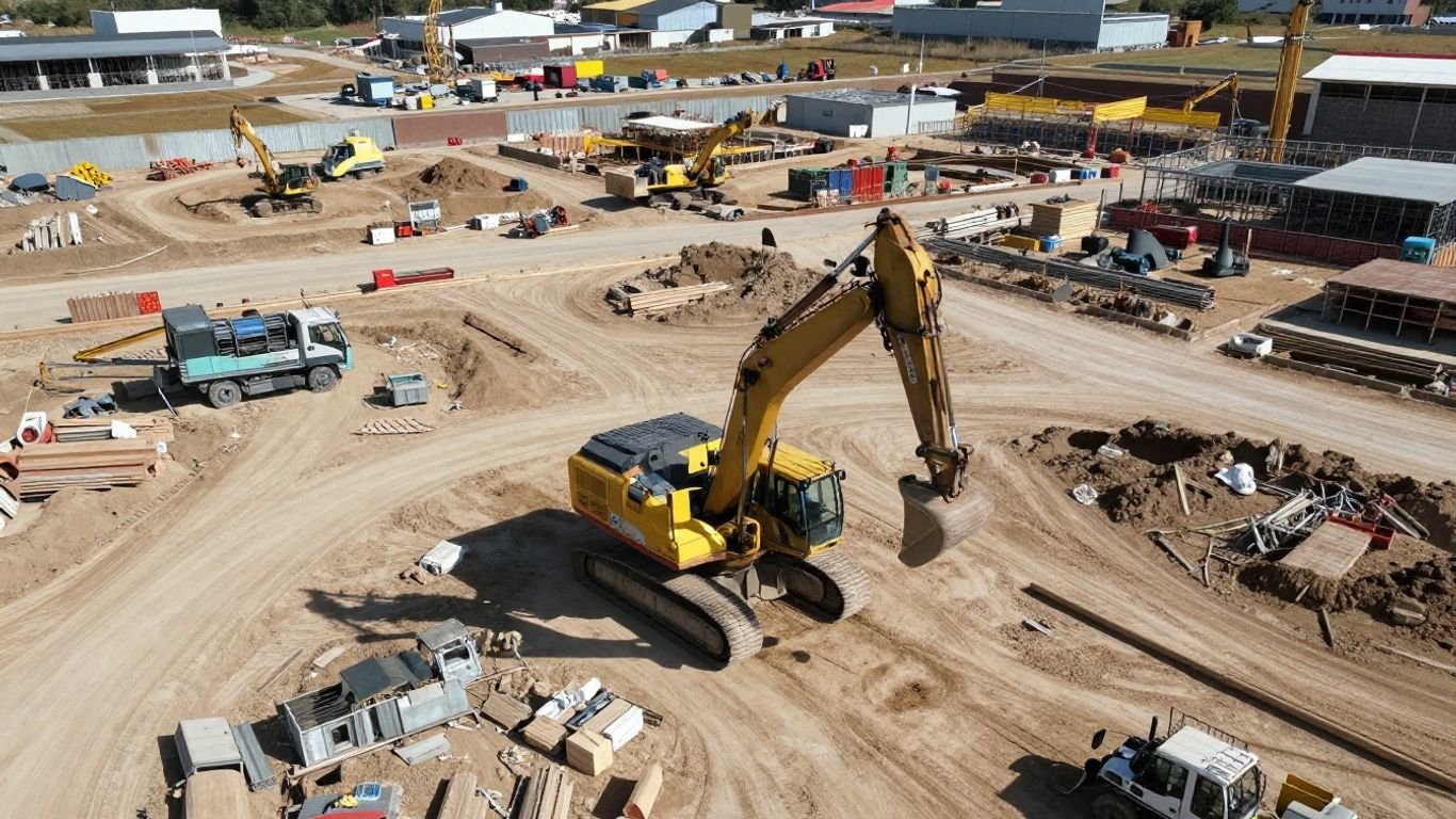
Keeping a project running smoothly often feels like juggling a dozen things at once. You need to know where your materials are, if your crew has what they need, and if everything is happening according to plan. Drone mapping really helps take some of the guesswork out of this. It gives you a bird’s-eye view that’s constantly updated, making it easier to see the big picture and the small details.
Real-Time Site Monitoring for Informed Decisions
Forget waiting for weekly reports that might already be outdated. With drones, you get a live look at your site. This means you can see exactly what’s going on, right now. Did a delivery arrive? Is a piece of equipment sitting idle when it could be used elsewhere? This kind of immediate information lets you make smarter choices about how to move forward, preventing small issues from becoming big problems.
Identifying Issues Early to Avoid Rework
One of the biggest drains on a project’s budget and schedule is having to redo work. Drone mapping can catch problems before they get out of hand. Maybe a foundation isn’t quite where it should be, or there’s a conflict between different parts of the design that wasn’t obvious from the ground. Spotting these things early means you can fix them without tearing down completed work, saving a lot of time and money.
Data-Driven Resource Distribution
Knowing where to put your resources – whether it’s people, equipment, or materials – is key to efficiency. Drone data provides the facts you need. You can see which areas are progressing well and which might need more attention. This allows you to shift resources where they’ll have the most impact, rather than just guessing or sticking to an initial plan that might no longer be the best fit. It’s about making sure your assets are working as hard as they can for you.
Here’s a quick look at how drone data can guide resource decisions:
- Equipment Placement: Determine the best spots for cranes, excavators, and other heavy machinery based on current site conditions and planned work zones.
- Material Staging: Identify optimal locations for storing materials and supplies, minimizing travel time for workers and vehicles.
- Labor Allocation: Understand where crews are working and if they have the necessary tools and materials, allowing for adjustments to prevent downtime.
Using drone mapping means you’re not just reacting to problems; you’re proactively managing your site with clear, visual information. This shift from reactive to proactive management is a game-changer for keeping projects on track and within budget.
Enhancing Project Planning and Cost Estimation
Getting a project off the ground right means having solid plans and knowing what it’s going to cost. Drone mapping really helps with both of these. It’s not just about pretty pictures from above; it’s about getting hard data that makes your planning more realistic and your budget estimates more accurate. This means fewer surprises down the road, which is always a good thing.
Faster Data Collection for Timely Estimates
Think about how long it used to take to measure a site by hand. You’d have surveyors out there for days, sometimes weeks, just gathering basic measurements. With drones, that whole process gets sped up a lot. We can capture detailed site information, like topography and existing structures, in a fraction of the time. This speed means you get the data you need for estimates much faster. So, instead of waiting around for survey results, you can start putting together your cost projections sooner. This quick turnaround is a big deal when you’re trying to get a project approved or get bids out.
Precise Measurements for Budget Adherence
Accuracy is key when you’re talking about money. Drones provide measurements that are incredibly precise. We’re talking about exact distances, heights, and volumes. This level of detail is super important for creating accurate quantity take-offs. Knowing precisely how much material you need – like concrete, gravel, or steel – helps you avoid ordering too much or too little. Over-ordering wastes money, and under-ordering can stop your project dead in its tracks. Precise measurements from drone data help you stick to your budget because you know exactly what you’re paying for.
Informed Material and Labor Costing
Beyond just material quantities, the data from drone mapping gives you a clearer picture for all sorts of costs. You can get detailed site dimensions that help in planning the layout of equipment and work zones, which impacts labor efficiency. Understanding the site’s terrain from above can also inform how much earthwork is needed, a significant cost factor. Plus, having a clear visual record of the site conditions helps in estimating the complexity of tasks, leading to more realistic labor hour allocations. It’s about using real, up-to-date site information to make smarter financial decisions from the very beginning.
The ability to get detailed, accurate site data quickly is a game-changer for project planning. It moves estimations from guesswork to informed calculations, directly impacting budget accuracy and project feasibility.
Here’s a quick look at how the data translates:
- Topographical Data: Helps estimate earthmoving costs and drainage planning.
- Existing Structure Dimensions: Aids in planning renovations or new constructions around current buildings.
- Site Coverage: Useful for calculating areas for paving, landscaping, or building footprints.
- Volume Calculations: Essential for estimating bulk materials like soil, sand, or aggregate.
This kind of detailed information, gathered efficiently, means your project plans are built on a solid foundation of facts, not assumptions. It makes a real difference in keeping projects on track and within financial targets met.
Elevating Accuracy for Complex Projects
When your project gets complicated, like a big infrastructure build or a tricky renovation, getting the details right is super important. Traditional ways of measuring and checking sites can take ages and sometimes miss things, especially in spots that are hard to get to. That’s where drones really shine.
Comprehensive Site Analysis from All Angles
Drones can fly all over your site, getting pictures and data from every single angle. This means you get a much fuller picture than just walking around with a tape measure. They can capture data from high up, from the sides, and even get into tight spaces. This helps you spot potential problems early on, like weird ground shapes or existing structures that might cause issues later. It’s like having a bird’s-eye view that can also zoom in on the nitty-gritty details. This kind of detailed site analysis is key for making sure your project starts off on the right foot.
Increased Efficiency in Data Acquisition
Think about how long it takes to survey a large construction site using old methods. It’s slow and can cost a lot. Drone surveys are way faster. They collect all the necessary information in a fraction of the time. This speed means you get your data back quicker, which helps keep your project on schedule. Plus, the data is ready to be turned into detailed drawings, like CAD files, much faster than before. This quick turnaround is a big deal for keeping projects moving.
Reduced Risk of Errors and Rework
Because drone surveys are so accurate, the chances of making mistakes in the design or during construction go way down. When you have precise measurements and a clear view of the site, you’re less likely to miscalculate materials or build something in the wrong spot. This accuracy helps keep your project within budget and avoids those costly fixes that happen when something is built incorrectly. It’s all about getting it right the first time, and drones help make that happen. For more on how this technology can benefit your work, check out premier drone photography services.
The precision offered by drone mapping means fewer surprises down the line. This translates directly into saved time and money, as well as a smoother construction process overall. It’s about building a solid foundation of accurate data from the very beginning.
Improving Collaboration and Communication
Think about how many times a project has hit a snag because someone wasn’t on the same page. It happens more often than you’d think. Drone mapping services really change that game. They create a single source of truth that everyone can access. No more digging through endless emails or trying to figure out which drawing is the latest version. Everyone, from the client to the folks on the ground, gets to see the same, up-to-date information.
Centralized Data Repository for Stakeholders
Imagine having all your project data – maps, 3D models, progress photos – in one spot. That’s what drone mapping provides. It acts like a digital hub for everything related to your site. This means less time spent searching for information and more time actually working on the project. It makes it easier for everyone involved to stay informed, whether they’re in the office or out in the field. This kind of organized data is a big help for keeping things moving smoothly.
Sharing Visual Updates and Reports
Forget static spreadsheets. Drone mapping lets you share visual progress reports that are easy to understand. You can show clients exactly where things stand with high-resolution images and 3D models. This transparency builds trust and helps manage expectations. It’s like giving everyone a virtual tour of the site, highlighting key areas and progress. This visual communication is a powerful way to keep stakeholders engaged and informed about the project’s status.
Real-Time Collaboration Platforms
Many drone mapping solutions come with platforms that allow for real-time collaboration. This means teams can comment on specific areas of a map or model, ask questions, and get answers quickly. It cuts down on back-and-forth communication and speeds up problem-solving. If an issue pops up, the team can discuss it right there on the shared data, making decisions faster. This kind of immediate feedback loop is invaluable for keeping complex projects on track and avoiding delays. It’s a big step up from waiting for the next site meeting to discuss a problem. You can even get your drone repaired if needed, ensuring your data collection isn’t interrupted nationwide drone repair services.
Having a clear, shared view of the project site helps prevent misunderstandings. When everyone is looking at the same accurate data, it’s much easier to align on goals and address challenges before they become major issues. This shared understanding is key to keeping a project on schedule and within budget.
Tracking Progress and Identifying Site Issues
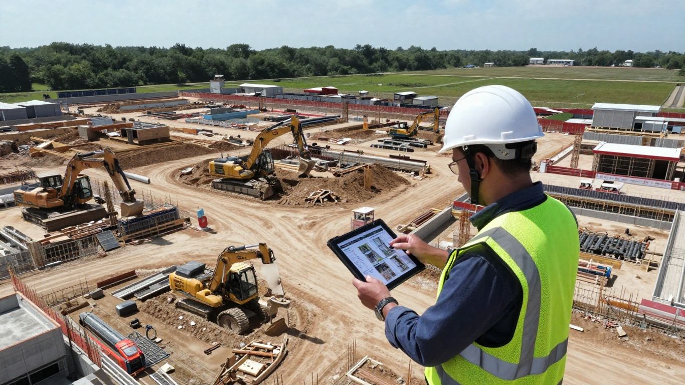
Keeping tabs on how a project is moving along can feel like a full-time job on its own. You’ve got schedules to meet, materials to track, and a whole crew to manage. Traditional methods often mean a lot of walking the site, taking notes, and then trying to piece it all together later. Drone mapping changes that game. It gives you a bird’s-eye view that’s constantly updated, making it way easier to see what’s happening and catch problems before they get big.
Automated Progress Monitoring Against Models
Imagine setting up your drone to fly over the site on a regular schedule. It captures all the latest photos and data. Then, the software compares this new information directly to your original design plans, like BIM or CAD models. It’s pretty neat because it can automatically point out where things don’t match up. This means you don’t have to spend hours manually checking every little detail. You get a clear report showing any differences, whether it’s a wall built in the wrong spot or a foundation that’s not quite right.
Timely Alerts for Deviations and Hazards
When the drone mapping software spots something off, it doesn’t just file it away. It can send out alerts right away. This could be for anything from a significant deviation from the planned layout to a potential safety issue, like equipment left in a dangerous spot or an area that looks unstable. Getting these alerts quickly means your team can react fast. It’s like having an extra set of eyes that’s always watching for trouble.
Actionable Insights for Bottleneck Resolution
Beyond just spotting problems, the data from drone mapping helps you figure out why things might be slowing down. You can see where materials are piling up but not being used, or if a certain area of the site is consistently behind schedule. This kind of detailed look helps you pinpoint bottlenecks. Once you know where the slowdowns are, you can make smarter decisions about how to fix them, whether that means moving more resources around or adjusting the work plan. It turns raw data into practical steps to keep the project moving smoothly.
The ability to compare current site conditions directly against digital models, coupled with automated alerts for any discrepancies, significantly reduces the chance of costly errors and delays. This proactive approach is key to maintaining project timelines and budgets.
Leveraging Drone Mapping for Municipal Planning
Municipal planning often involves juggling limited resources with big responsibilities, from keeping infrastructure in good shape to managing environmental concerns and sticking to project timelines and budgets. Drone technology is really changing the game for how cities plan, check on, and manage important assets. It’s all about using geospatial services and remote sensing to get a clearer picture.
Accurate Planning for Infrastructure Projects
When it comes to planning new roads, utility lines, or other public works, accuracy is everything. Traditional surveying methods can be slow and costly, especially in tough spots. Drones, however, can quickly capture detailed aerial imagery and create precise 2D maps and 3D terrain models. This means less time spent on the ground and more reliable data for your designs. This technology supports smarter development strategies by providing granular data, reducing reliance on traditional methods, and enabling more efficient and informed decision-making for urban growth.
Documenting Asset Conditions for Management
Keeping track of city assets like bridges, water towers, or even pavement conditions is a big job. Drones make these inspections safer and more efficient. Instead of sending crews into potentially hazardous situations, drones can capture high-resolution and thermal images from a distance. This visual documentation is invaluable for assessing asset health, planning maintenance, and even for public communication or funding requests. Data collected can be fed directly into municipal GIS and asset management systems, giving you a current view of your infrastructure.
Informed Capital Improvement Decisions
Making smart choices about where to invest capital improvement funds requires solid data. Drone mapping provides that data. It helps in:
- Tracking erosion or flooding patterns for environmental planning.
- Assessing vegetation and wetland health for compliance.
- Getting a clear view of pavement conditions for road repair prioritization.
- Locating hidden infrastructure like sewer manholes, even in overgrown areas.
The ability to gather precise, up-to-date information quickly allows city leaders to make better-informed decisions about budget allocation and project priorities, ensuring public funds are used most effectively.
By partnering with experienced professionals who know both drone technology and municipal needs, cities can avoid common pitfalls and get reliable results. This approach helps stretch budgets further and serve residents more effectively, transforming data into actionable insights for the community. You can explore more about how drone technology aids urban planning by looking into drone mapping services.
Wrapping It Up
So, there you have it. Drone mapping isn’t just some fancy new gadget; it’s a seriously practical tool that can make a real difference in how your projects run. From getting super accurate site details way faster than before, to keeping a constant eye on progress and spotting problems early, it just makes sense. It helps everyone stay on the same page, cuts down on mistakes, and ultimately saves you time and money. If you’re looking to get more done with fewer headaches, giving drone mapping services a shot is definitely worth considering for your next project.
Frequently Asked Questions
What exactly is drone mapping?
Drone mapping uses special drones with cameras and sensors to take lots of pictures and gather data from above. This information is then put together using computer programs to create detailed maps, 3D models, and other useful visuals of a project site.
How is drone mapping faster than old methods?
Instead of people walking around with measuring tools, drones can cover large areas quickly. They capture tons of data in a short time, and computers process it much faster than manual calculations, saving a lot of time.
Can drone mapping help save money?
Yes! By getting accurate measurements and spotting problems early, drone mapping helps avoid costly mistakes and rework. It also helps plan better, so you order the right amount of materials and use your workers and equipment more efficiently.
Who uses drone mapping services?
Many people use it! Builders, city planners, engineers, and construction managers use it for things like building new roads, designing houses, managing city resources, and checking the progress of big projects.
Does drone mapping make projects more accurate?
Absolutely. Drones can get super precise measurements, even in tricky spots that are hard to reach. This means the maps and models created are very accurate, leading to better planning and fewer errors during building.
How does drone mapping help teams work together?
Drone mapping creates a central place for all the project information, like maps and 3D models. Everyone on the team, from the boss to the workers, can see the same up-to-date information, making it easier to communicate and make decisions together.