
A comprehensive guide to the eBee TAC AgEagle Aerial Systems tactical drone
Key Takeaways
The eBee TAC AgEagle Aerial Systems offers a combination of rapid deployment and precision data collection, making it a versatile tool for modern field operations. Here are the core highlights of this platform:
- Engineered for rapid setup by a single operator in under three minutes.
- Features robust, cyber-secure data transmission protocols to protect sensitive mission intelligence.
- Provides flexible sensor payloads, supporting both high-resolution visual and thermal imaging requirements.
- Designed for high energy efficiency, enabling longer flight times in challenging tactical environments.
- Compatible with international military grid systems to ensure seamless integration with existing command structures.
Core design specifications of the eBee TAC
The eBee TAC is engineered for performance in demanding environments where operational speed and reliability are paramount. By balancing mechanical simplicity with advanced modular avionics, the system provides a predictable platform for commanders and field operators alike. Every component is selected to ensure the unit functions correctly during intensive duty cycles, minimizing the need for complex maintenance during critical short-duration missions.
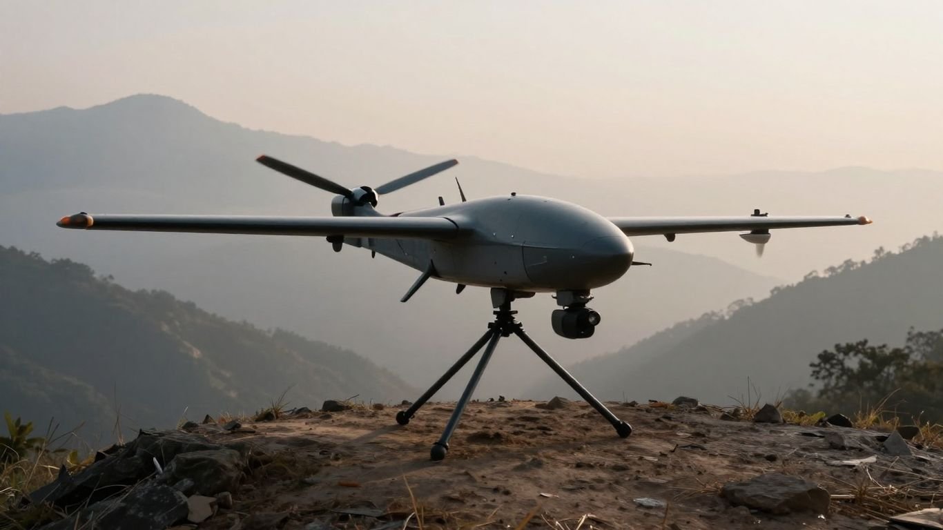
Lightweight construction for rapid field deployment
The frame emphasizes portability without sacrificing structural integrity, ensuring that operators can transition from transit to flight with minimal delay. This efficiency reduces the physical burden on personnel moving through difficult terrain while maintaining a mission-ready state. The modular design further permits rapid field deployment as the primary focus, allowing one trained operator to successfully launch the system efficiently.
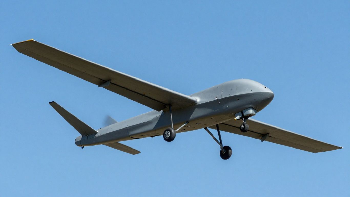
Flight endurance and performance metrics in tactical scenarios
Efficiency in energy consumption translates to sustained situational awareness on the ground. The fixed-wing design optimizes glide ratios and drag resistance, permitting the platform to remain on station longer than many multi-rotor counterparts. Whether conducting a sweep or monitoring a static position, the system achieves a calculated balance of speed and battery longevity.
Stealth characteristics for covert intelligence operations
Operating in sensitive areas often requires technology that minimizes visibility to opposing forces. The aircraft utilizes an airframe silhouette and propulsion system that maintains a low acoustic profile during standard cruising altitudes. This reduction in detection risk is intended to keep intel-gathering quiet, preventing compromise while personnel conduct covert intelligence operations near hostile zones.
Resilience and durability in harsh climate environments
The underbody skin consists of advanced thermoplastic composites designed for impact resistance, particularly during repeated landings on unrefined surfaces. This robust construction ensures that mission equipment remains shielded from debris and environmental hazards often encountered in remote operating locations. Operators can rely on the durable modular design to endure the physical rigors of consistent field utilization.
Tactical reconnaissance and surveillance applications
Advanced unmanned systems translate high-altitude perspectives into actionable strategic intelligence for ground-based personnel. Effective reconnaissance requires the seamless fusion of hardware and software to ensure that data captured in a remote environment can be understood and acted upon immediately. When deployed correctly, these autonomous tools serve as an extension of the infantry’s vision, closing the information gaps found in complex or denied terrain.
Enhancing situational awareness in denied environments
A primary goal of tactical aviation is to provide a complete operational picture despite local interference. Modern platforms utilize encrypted communication to ensure the link remains stable, even if jamming or signal degradation is a concern. By maintaining this connectivity, analysts receive constant updates that prevent tactical surprises during high-stakes engagements.
Target acquisition and tracking protocols for field units
Integration with mission software allows operators to designate zones of interest and track moving subjects with high precision. This tracking capability is vital for maintaining eyes on potential threats while managing limited battery resources. The ability to lock onto coordinates ensures that intel gathered is accurate and relevant to the current tactical posture.
Support for dismounted infantry and special operations
When small units are operating independently, having immediate aerial oversight becomes a force multiplier for field units. This accessibility ensures that those furthest from command can confirm ground conditions without exposing scouts to direct fire. The compact transport nature of the gear ensures it travels wherever the soldier travels, maintaining mobility alongside firepower.
Integration with existing battlefield management systems
Interoperability is a requirement for modern units that rely on standardized mapping protocols to communicate spatial information. By utilizing systems like the Military Grid Reference System (MGRS), the platform ensures every coordinate produced is immediately usable by third-party command tools. This seamless data exchange reduces interpretation delays and keeps every tier of the command structure informed.
Advanced sensor payloads and data collection
Collecting high-fidelity evidence from the air requires a variety of sensor architectures tuned for different lighting and environmental conditions. Because no single sensor is sufficient for every mission type, the capability to quickly swap payloads allows operators to tailor their approach based on the immediate requirement. Utilizing such advanced sensor payloads requires a robust foundation in understanding how optics and thermal data interact with target environments.
High-resolution optical imaging for visual reconnaissance
For daylight identification, high-megapixel sensors provide the detail necessary to differentiate between innocuous objects and tactical targets. These images are processed locally or post-flight to generate orthomosaics which help confirm terrain features. Quality visual data remains the backbone of initial reconnaissance efforts, providing context for later follow-up assessments.
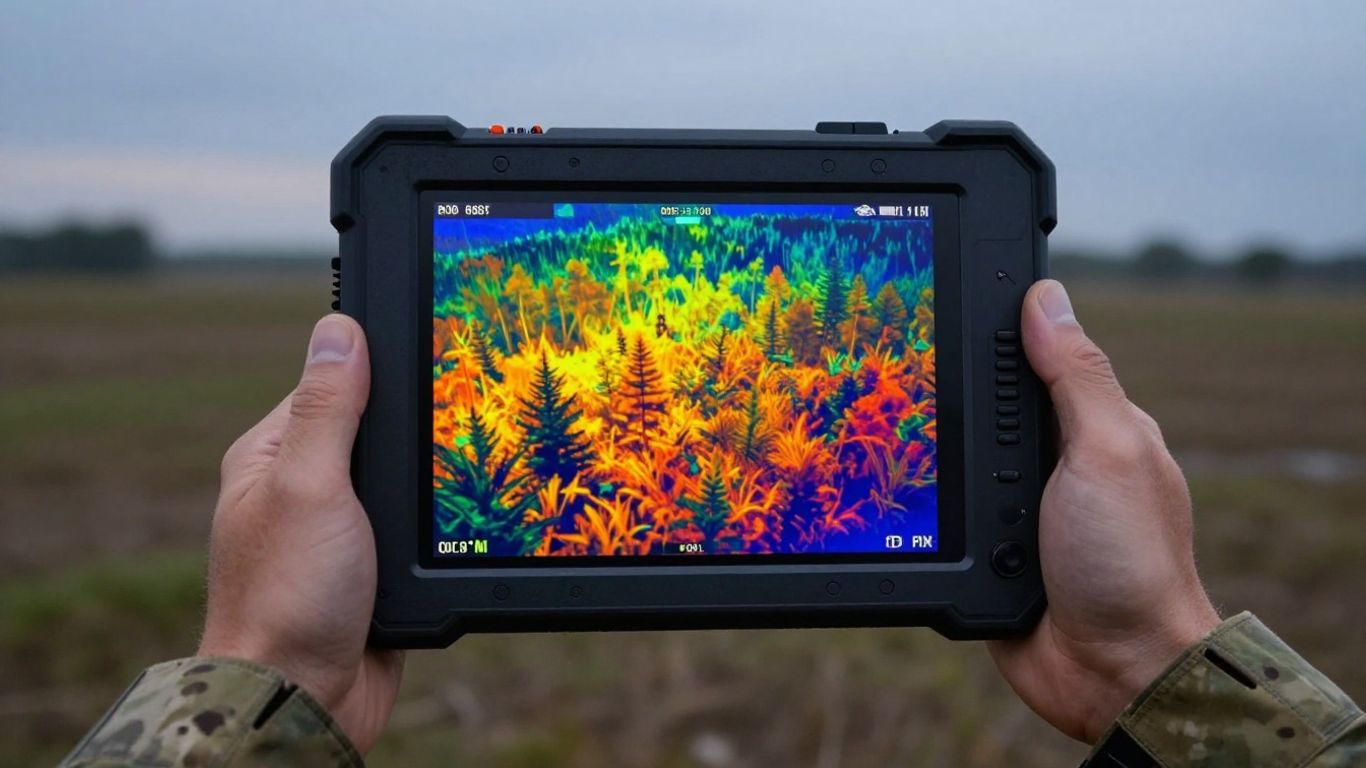
Thermal and infrared sensor configurations for night ops
Thermal technology allows field units to operate after sunset, detecting heat signatures that are invisible to the naked eye. This capability is essential for identifying concealed assets and personnel in dense vegetation or urban environments where visual detection reaches its limit. By understanding the key components of thermal cameras, units can optimize their gain settings to distinguish subtle thermal transitions.
Real-time data processing and secure transmission
Data utility often depends on how quickly it reaches the decision-maker. Through dedicated onboard processing and secure downlink channels, systems can stream critical findings directly to local controllers or command receivers. Ensuring this aerial information protection remains a priority, as compromising raw data risks mission security in any theater.
Precision mapping and 3D terrain modeling capabilities
Digital elevation models generated from aerial photography provide a unique advantage in planning movement through unpredictable terrain. Using software-based photogrammetry, units convert raw imagery into accurate 3D maps that expose elevation changes or hidden obstacles. This level of mapping accuracy informs everything from logistical routing to fire control solutions.
Standard operating procedures for field deployment
| Process Step | Primary Objective | Safety Requirement |
|---|---|---|
| Site Survey | Identify flight hazards | Local airspace clearance |
| Pre-flight Build | Calibrate avionics suite | Battery voltage validation |
| Launch Protocol | Stable hand-release | Clear horizontal trajectory |
| Landing Recovery | Controlled touchdown | Unobstructed landing zone |
Standardized procedures are the backbone of repeatable, mission-ready performance in the defense sector. These protocols are designed to minimize operator error, especially during high-stress moments or under degraded environmental conditions where fatigue may affect judgment. Adherence to established sequences ensures that the system is calibrated before each takeoff, preventing minor oversight from causing significant mission failure.
Rapid hand-launch techniques and setup times
Speed is a crucial requirement for operations where the objective is time-sensitive. By simplifying the assembly process, operators can go from transport case to airborne in minutes, capitalizing on short windows of opportunity. This ease of launch is essential for small teams that must remain agile in the field without extensive logistics support.
Autonomous flight planning and mission customization
Advanced flight software automates the most tedious aspects of navigation, allowing the pilot to focus on sensor oversight. Users define waypoint boundaries and altitude constraints, which the aircraft follows until the mission concludes. This level of autonomy is standard for modern tactical platforms, ensuring the flight path is maintained reliably even if the pilot needs to manage concurrent ground tasks.
Recovery methods in remote or confined geographic areas
When a site lacks a traditional runway or clear landing strip, the system uses belly-landing techniques designed for rugged environments. By prioritizing a shock-absorbent construction, the airframe minimizes damage during contact with rough ground. Operators must identify the landing vector early, ensuring the terminal descent occurs away from obstacles or terrain hazards.
Training requirements for military and defense operators
Competence with tactical equipment involves deep familiarity with both hardware and regulatory frameworks. Training programs ensure that operators understand the limitations of the system, including how to handle emergencies if flight telemetry is lost. Maintaining consistent certification standards ensures that personnel remain prepared to operate effectively under diverse mission profiles.
Logistics and ecosystem support by AgEagle
Long-term operational success depends on the logistical tail that keeps the equipment serviceable and up to date. Support networks must handle the nuances of global operations, ensuring that spare parts, software patches, and guidance reach the units even when they are stationed in disconnected or remote sectors. Building this ecosystem requires a collaborative approach between the provider and the end-user to address real-world challenges.
Spare parts availability and battery management strategies
Maintaining a functional fleet requires anticipating wear and tear long before it compromises an active mission. Regular inventory checks of motors, propellers, and battery cells ensure that no unit remains grounded for want of a simple repair. For teams in the field, this means having a reliable chain of supply that can assist with recovery and review after an incident occurs.
Software updates and firmware maintenance for security
Digital threats evolve rapidly, making regular firmware updates a necessary part of system ownership. These patches refine internal logic, improve communication resilience, and close potential vulnerabilities that could undermine mission integrity. Secure maintenance practices are vital, ensuring that protecting sensitive aerial information remains at the forefront of every update cycle.
Integration with third-party analytical and GIS software
Data collected in the field is rarely an end state; it must usually be ingested into larger command information systems. Working with industry-standard formats allows units to correlate drone-gathered imagery with existing GIS data layers for a more comprehensive map. This compatibility ensures the raw input can be transformed into deep analytical insight for commanders.
Regulatory compliance and logistical export considerations
Moving hardware across borders involves complex legal landscapes and export controls. AgEagle manages the necessary documentation and compliance standards to help customers navigate international requirements, ensuring that systems reach the destination legally and on time. This global logistical support is foundational to successful adoption across international defense markets.
Conclusion
The eBee TAC represents a highly capable asset for tactical intelligence gathering, providing teams with the speed, endurance, and data precision required in contemporary security environments. By leveraging the comprehensive ecosystem and modular architecture inherent in the system, operators can maintain consistent mission success across a wide range of operational theaters. Future advancements in these platforms will likely continue to emphasize greater autonomy and tougher hardware configurations, further cementing the role of lightweight fixed-wing UAVs in modern defense doctrine.
Frequently Asked Questions
What is the typical flight ceiling for small tactical drones?
Most tactical systems are designed to operate at altitudes that balance sensor focal length with acoustic camouflage, typically staying well within the range of professional flight envelopes that avoid low-altitude ground obstacles.
Can these drones operate in GPS-denied environments?
Yes, tactical platforms often utilize advanced inertial navigation systems that allow them to maintain flight stability and data acquisition even when satellite signals are obstructed or intentionally jammed.
How are batteries managed in sub-zero or high-heat zones?
Battery management protocols often involve pre-heating or cooling strategies, often supported by cases that provide insulated storage until the moment of integration with the drone.
Are 3D models generated instantly or post-flight?
While some edge-computing units can perform limited real-time visual assessment, high-fidelity 3D terrain modeling usually requires post-flight software processing to render and stitch the imagery into a complete map.
Is it possible to use these systems with non-native sensor payloads?
Most platforms are optimized for specific manufacturer-approved sensors to ensure compatibility with the firmware and flight dynamics, rather than supporting a wide array of generic or third-party camera hardware.
How much training is needed to proficiently operate these units?
Professional proficiency generally follows a structured training path that introduces basic safety, regulatory understanding, and advanced mission planning, often lasting several weeks to ensure full competency in a range of scenarios.
Do these drones record video for evidentiary purposes?
Many units include encrypted internal recording features that capture flight telemetry and visual input, which can be protected and stored for follow-up analysis after the mission has concluded.